

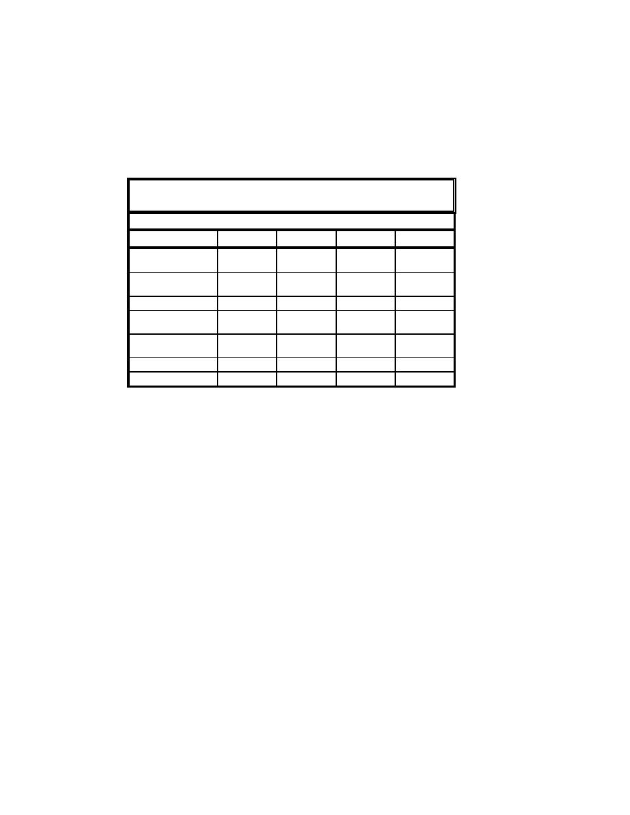
To quantify areal changes of the flood shoal at Mattituck Inlet from 1935 to
1938, each lobe was divided into two sections, the portion that lies below mlw
datum, and the portion that is above mlw. The attached spit, located at the base
of the east jetty and not considered to be a portion of the flood shoal proper, is
also analyzed. Table 4-2 lists the corresponding areas for each portion of the
flood shoal in square feet.
Table 4-2
Mattituck Inlet Flood Shoal Area 1935-1938
Area (sq ft)
Year
1935
1936
1937
1938
West lobe
77,000
55,800
66,000
30,100
below mlw
West lobe
48,800
63,200
75,600
81,000
above mlw
125,800
119,000
141,600
121,100
West lobe total
East lobe
107,200
33,400
61,900
66,800
below mlw
East lobe
50,500
21,500
25,200
45,100
above mlw
157,700
54,900
87,100
111,900
East lobe total
283,500
174,400
228,700
233,000
Flood shoal total
Volumes dredged from Mattituck Inlet during November 1935 to May 1936,
the annual volume of shoaling within Mattituck Inlet, and the volume of channel
infilling for the period 1936 through 1938, were calculated by differencing
bathymetry surfaces digitized from the original survey sheets. Difference
surfaces generated by map calculations of raster grids for each survey are
analyzed to understand the observed volume change. To quantify volume
changes, TIN's were generated for each condition survey, and the volume for
each TIN was calculated. Volume changes were calculated for the entire study
area and a selected portion of the Federal navigation channel (to estimate the
average rate of channel infilling). The volumes calculated represent those of
sediment in the study area found above a datum located beneath the lowest
elevation contained in the grids considered.
Each lobe of the flood shoal was divided into two sections, the portion
outside the navigation channel and the portion inside the navigation channel.
The volume above a selected datum was then calculated for each TIN. For the
portions outside the navigation channel, a reference datum at a depth of 3 ft mlw
was specified, corresponding to be the average ambient depth outside the
channel. For the portion within the navigation channel, a reference datum at a
depth of 9 ft mlw was specified, corresponding to the average depth after
dredging. The volume and area of each portion of the flood shoal are listed in
Table 4-3. This method does not necessarily consider shoaling along the sloping
walls of the Federal navigation channel, which may introduce error.
124
Chapter 4 Morphology Change, and Channel Shoaling and Migration

 Previous Page
