

200
250
Gulf Wave Climate
Constant Kt
Atlantic Wave Climate
Constant Kt
Variable Kt
Variable Kt
200
150
150
100
100
50
50
0
0
-50
-50
0
1000
2000
3000
0
1000
2000
3000
Distance Alongshore (m)
Distance Alongshore (m)
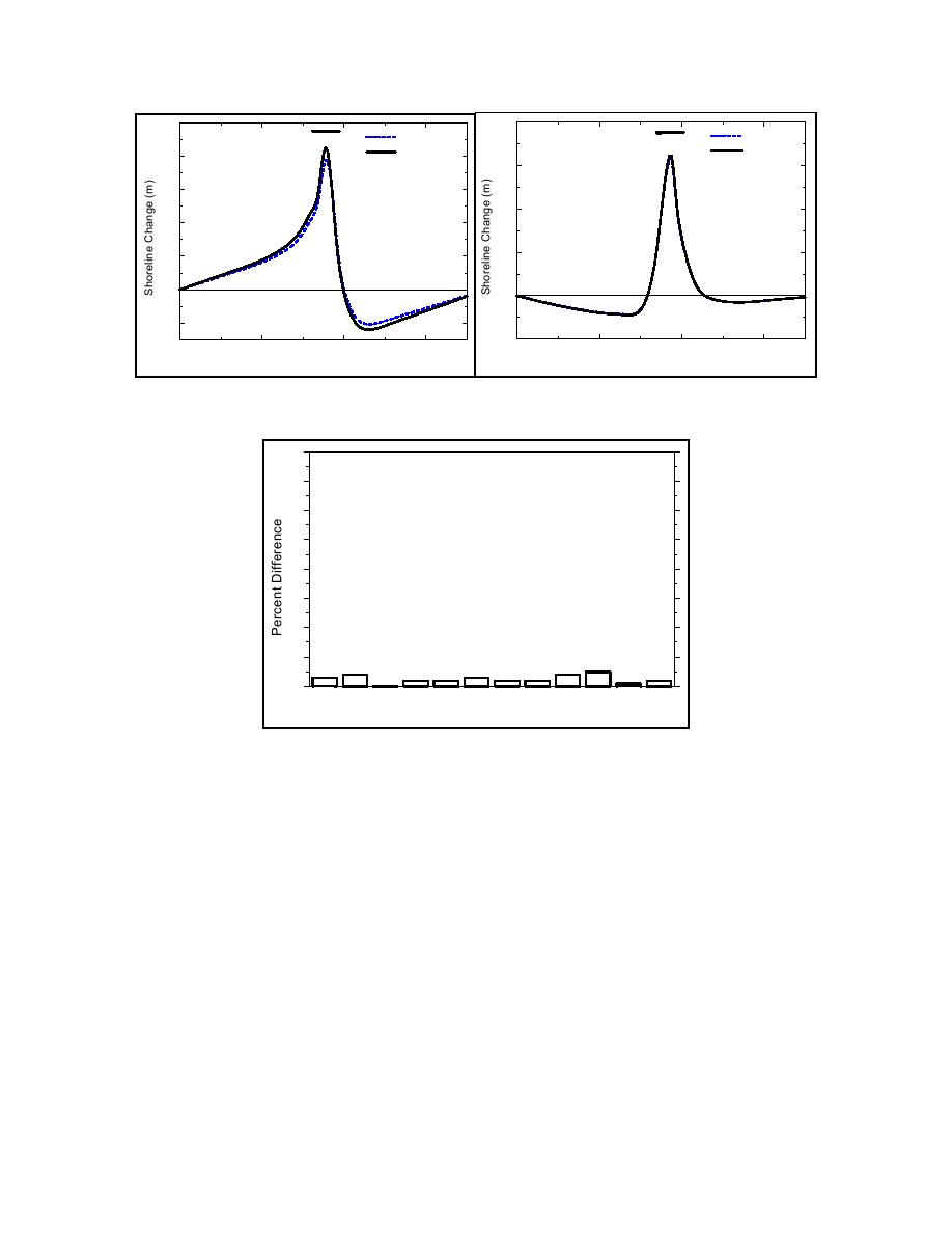
Fig. 7. Shoreline change behind emergent high breakwater
80
70
60
50
40
30
20
10
0
Jan
A8 g S9 p O0t Nov Dec
F2 b Mar
e
Apr May Jun
Jul
u
1c
e
1
3
4
5
6
7
11
12
Month
Fig. 8. Percent difference in shoreline change behind emergent
high structure between constant and time-dependent Kt
calculation methods, by month
CASE STUDY GRAYS HARBOR, WA
Predictions of the model for submerged structures was further examined in application to a
functional design of a submerged spur being studied as a possible sediment-control measure for the
north jetty at Grays Harbor, WA (Figure 9). Grays Harbor, located on the Pacific Ocean coast of the
USA, is one of the largest estuaries in the continental United States. The tide is semi-diurnal with 2-
to 3-m neap to spring typical range. The adjacent beaches have a slope of approximately 1 on 60
and median sand grain size of 0.25 mm. A high-energy wave climate produces average annual
significant wave heights of 2 m and peak periods of 10 s. However, winter storms generate waves
greater than 6 m high and 17-s period.
The entrance to Grays Harbor is bounded on both sides by rubble mound jetties. The north jetty
was constructed to block southward transport of sediment and to protect and maintain the entrance
navigation channel (USACE 1973). The effectiveness of the north jetty has decreased because of
subsidence and deterioration, resulting in sediment being transported into the inlet, potentially
Wamsley et al
7

 Previous Page
