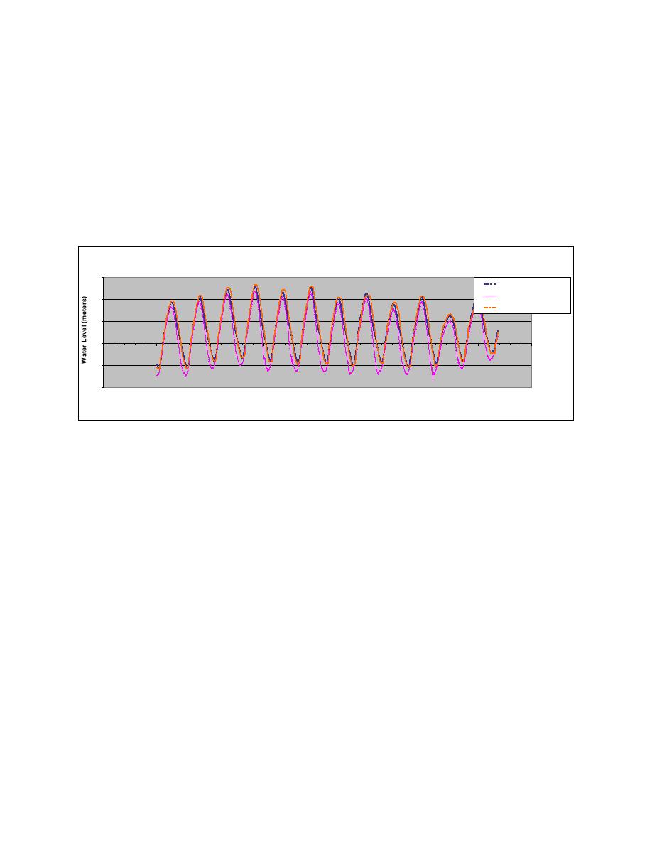
Banks Channel and the AIWW are compared approximately 3 weeks after inlet opening during a
spring tidal cycle. The ranges of water level were equivalent at 1.48 m at the Mason Creek and
1.52 m at the AIWW locations during this period of time, a 1-mi phase lag at the AIWW site was
observed (Fig. 7). Currents within the reopened Mason Creek channel exceeded 1.5 m/sec
(4.5 ft/sec) decreasing 6 months after the inlet's opening to a maximum a maximum of 0.5 to
0.7 m/sec (1.6 to 2. ft/sec) following initial equilibration of the channel cross-section occurring
during the first 3 months (i.e., July 2002). October 2002 surveys show minor adjustment of the
cross-section with maximum velocities remaining nearly equivalent based on observations of
flow from June through December 2002 in Mason Creek. In contrast, Banks Channel has
experienced a gradual reduction in velocities with significant shoaling along the southernmost
460 m (1,500 ft) inlet entrance section.
Comparison of Water Levels at Banks Channel, Mason Creek and the AIWW
1.5
Banks Channel
Mason Creek
1.0
AIW W
0.5
0.0
-0.5
-1.0
26-Mar-02
27-Mar-02
28-Mar-02
29-Mar-02
30-Mar-02
31-Mar-02
1-Apr-02
2-Apr-02
3-Apr-02
Time (Date)
Fig. 7. Seven-day comparison of water levels during first spring tidal cycle after reopening of Mason
Creek Channel and New Mason Inlet
In the design-development phase of this Project, calculations were made to predict changes in
tidal dominance and tidal prism of Masonboro Inlet, Mason Inlet, and Rich Inlet expected from
the construction of the new Mason Inlet and Mason Creek channels. The design tidal prisms at
neap and spring tide were calculated by a 2D depth-averaged hydrodynamic model to be
52x106 m3 (170 - 200x106 ft3). The model results predicted that the tidal prism would increase
150 percent at Mason Inlet. At Masonboro and Rich Inlets, a slight reduction in tidal prism was
expected to occur. Maximum tidal volumes predicted by the model for the 140-ft wide Mason
Creek channel were expected to result in a tidal flow distribution of 40 percent through the newly
dredged Mason Creek Channel and 60 percent through Banks Channel. Tidal prism calculations
indicate that the tidal flow distribution was nearly equal (51:49 distribution between Mason
Creek and Banks Channel) in April and May 2002 with tidal flows gradually shifting from Banks
Channel to Mason Creek channel (65:35) from June through November 2002.
Computations of tidal prisms at the three monitoring locations were developed based on
periodic surveys of the channel cross-sections, water level variations at 3- to 6-min intervals and
until the direction of flow reverses. Prior to construction of the project, tidal and current studies
at Mason Inlet indicated that the inlet was flood dominant, and predicted to be flood dominant
following reopening of the new inlet. Tidal prisms computed for Mason Creek and Banks
Channel after project construction indicated that the inlet is flood dominant. Immediately upon
the inlet and channel opening, a 3 to 6 percent greater flow occurred during a flood tidal
9


 Previous Page
