ACKNOWLEGEMENTS
We would like to
dedicate this work and our
adventures to the memory
of Jon H. Anderson (1947-
2003).
Geodynamics
sincerely thanks Captain
Reed Robinson, Corey
Allen,
and
John
McCormick for field
support. We would also
like to recognize Reed
Meredith and the staff at
the Waterworks in Nags
Head, NC, for their
emergency assistance.
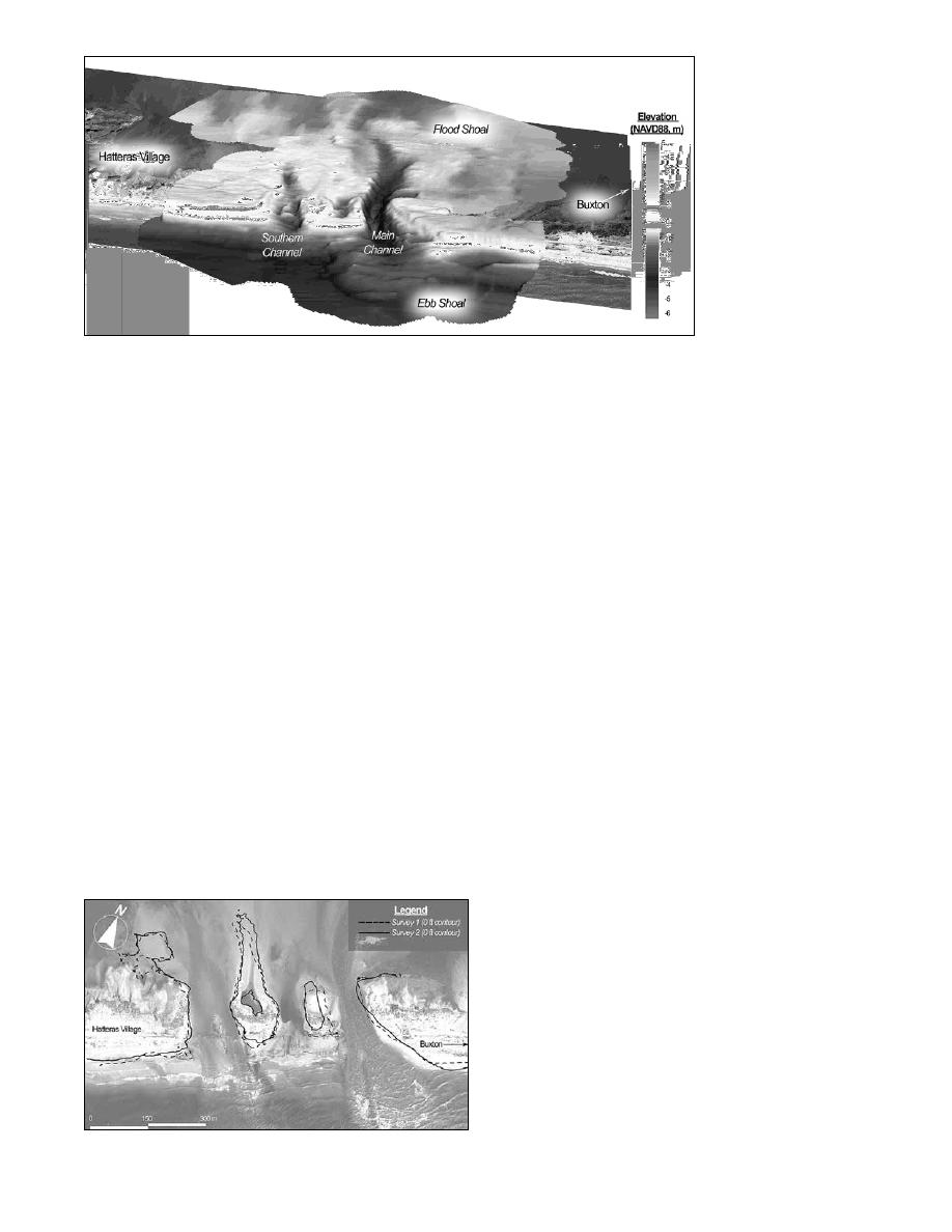
Figure 7. Detailed 3D DEM of the Hatteras Breach.
morphology.
REFERENCES
To rapidly generate these high-resolution surfaces, produce
Beach, R.A., Holman, R.A., and Stanley, J. 1996. Measuring Nearshore
detailed grid statistics, and manage and integrate the large
Bathymetry on High Energy Beaches, Book of Abstracts, American
datasets from the Hatteras breach, a combination of proprietary
Geophysical Union Fall Meeting, pp. F286.
and Open Source GIS applications were applied. The efficiency
Bernstein, D.J., Freeman, C.W., Park, J., Forte, M.F., Gayes, P.T., and
of GIS in processing and visualizing these spatial data provided
Mitasova, H. 2003. Spatial Survey Design Analysis for 3D Mapping
of Beach and Shoreface Morphology, Proceedings International Con-
the USACE Wilmington District design team with an immediate
ference on Coastal Sediments 2003, CD-ROM Published by World
and simple means to assess and aid in the ultimate closure of the
Scientific Publishing Corp. and East Meets West Productions, Corpus
breach (Wutkowski 2004). Figure 8 demonstrates the integration
Christi, TX, USA, ISBN 981-238-422-7.
of contour-based shorelines extracted from the topo/bathy DEM
Bernstein, D.J., Hesser, T.J., Ojeda, G.Y., Freeman, C.W., Gayes, P.T., and
Forte, M.F. 2004. Evaluating the Significance of Shoreline Indicators
of the Hatteras breach draped on a 1 m resolution NCDOT digital
Commonly Used to Assess Shoreline Change, GSA Abstracts with
orthographic quarter quadrangle using GIS.
Programs, Vol. 36, No. 2.
Freeman, C.W., Bernstein, D.J., Wells, J.T., Mitasova, H. 2003. Spatio-
CONCLUSIONS
Temporal Variability in Three-Dimensional Coastal Morphology:
Bogue Banks, North Carolina, Proceedings International Conference
Morphological assessment at the site of the Hatteras breach
on Coastal Sediments 2003, CD-ROM Published by World Scientific
Publishing Corp. and East Meets West Productions, Corpus Christi,
with SANDMAP illustrates the utility of combining modern
TX, USA, ISBN 981-238-422-7.
mapping instrumentation, detailed 3D spatial data collection
List, J.H., and Farris, A.S. 1999. Large-scale Shoreline Response to
techniques, and a managed and flexible survey strategy. These
Storms and Fair Weather, Proceedings Coastal Sediments `99, ASCE,
methods provide an accurate and cost-effective means of
Reston, VA, pp. 1,324-1,338.
MacMahan, J. 2001. Hydrographic Surveying from Personal Watercraft,
collecting spatial and temporal information previously
Journal of Surveying Engineering 127(1), 12-24.
unattainable with traditional 2D techniques. The superior
Mitasova, H., Drake, T., Bernstein, D.J., Harmon, R. 2003. Quantifying
mobility of the SANDMAP surveying systems deployed at the
Rapid Changes in Coastal Topography Using Modern Mapping Tech-
niques and GIS, Proceedings International Conference on Coastal
site of the Hatteras breach illustrates the rapid-response
Sediments 2003, CD-ROM Published by World Scientific Publishing
technology necessary to collect data following a natural disaster
Corp. and East Meets West Productions, Corpus Christi, TX, USA,
such as Hurricane Isabel. Processing and analyzing these
ISBN 981-238-422-7.
massive datasets is significantly aided with proprietary and Open
Mitasova, H., Drake, T.G., Harmon, R.S., Bernstein, D.J. 2004. Quantify-
ing Rapid Changes in Coastal Topography Using Modern Mapping
Source GIS applications. These data analysis tools allowed the
Techniques and GIS, Environmental and Engineering Geosciences, In
coastal management community to easily assess the breach
press.
geomorphology and appropriately engineer closure of the
Morton, R.A., Leach, M.P., Paine, J.G., Cardoza, M.A. 1993. Monitoring
Hatteras breach.
Beach Changes Using GPS Surveying Techniques, Journal of Coastal
Research 9(3), 702-720.
Park, J.-Y. 2002. Beach-profile Analysis MATLAB-tool (BAM) V. 0.1.
Center for Marine and Wetland Studies, Coastal Carolina University,
SC, in progress.
Ruggiero, P., Kaminsky, G.M., and Gelfenbaum, G. 2004. Linking Proxy-
Based and Datum-Based Shorelines on a High-Energy Coastline: Im-
plications for Shoreline Change Analyses, Journal of Coastal Re-
search, SI 38, pp 57-82.
Wamsley, T., and Edge, B.L. 2001. Shoreline Monitoring Program on the
Texas Coast by Real-Time Kinematic Differential Global Positioning
System, Shore and Beach 69(4).
Wamsley, T.V., and Hathaway, K.K. 2004. Monitoring Morphology and
Currents at the Hatteras Breach, Shore and Beach 72(2), 9-14.
Wong, C., Riley, J.L., Martin, D., Huff, L.C., Hall, L., Gill, S., Foote, R.,
Carlson, E. 2000. NOS RTK Team Final Report, Office of Coast
Survey Center for Operational Oceanographic Products and Services
Office of National Geodetic Survey, Silver Springs, MD.
Wutkowski, M. 2004. Hatteras Breach Closure, Shore and Beach 72(2), 20-24.
Figure 8. Contour change map.
Shore & Beach Vol. 72, No. 2, Spring 2004, pp. 3 - 7
7


 Previous Page
