W. Huang et al. / Ocean Engineering 30 (2003) 22752295
2279
application for wave forecasting dealt with three stations in the vicinity of a harbor
that are within a relatively small spatial scale.
In the study described in this paper, the long-term water levels consist of both
tidal and non-tidal signals. Because of shallow water effects and the long distance
(above 60 km) between the south shore inlets and the remote NOAA tidal stations,
there are substantial differences in the amplitude and phases of water levels between
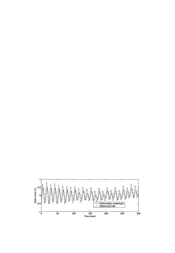
NOAA stations and local stations at south shore (Fig. 2). The nonlinearity and phase
difference were considered as major obstacles in the application of ANN by Hsieh
and Tang (1998). Hagan et al. (1995) describe several different algorithms in neural
network development. Using adequate network structure and training algorithm has
effects on the ANN model performance. The following sections present the tech-
niques in the development of an ANN model to predict water levels in large regional
coastal waters where considerable differences exist in the phase and amplitude of
the water levels, and non-periodic sea level variations.
3. Backpropagation neural network methodology
In analogy to the biological nervous system, ANN technology is being applied to
solve a wide variety of complex scientific, engineering, and business problems. Neu-
ral networks are ideally suited for such problems because, like their biological
counterparts, ANNs can learn, and therefore be trained to find solutions, recognize
patterns, classify data, and forecast future events. Hagan et al. (1995) and Haykin
the neural networks. In a neural network model, the outputs are correlated to the
inputs through the neurons (or nodes) with weights and bias. The behavior of a
neural network is defined by the way its individual computing elements are connected
and by the strength of those connections or weights. The weights are automatically
adjusted by training the network according to a specific learning rule until it performs
with the desired error rate.
Fig. 2. Time series of water levels in the region of Long Island south shore show the difference of
magnitude and phases between inlet station and NOAA station.


 Previous Page
