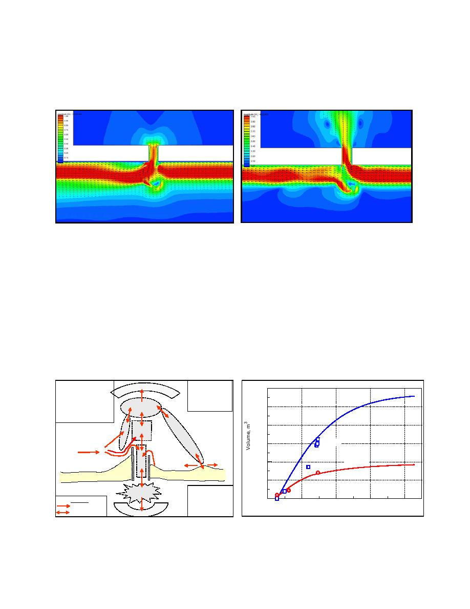
As an application, Militello and Kraus (2001) describe the consequences of mining the flood
shoal at Shinnecock Inlet, NY as a sand resource. Analysis of circulation model calculations
showed changes in current speed at the inlet, navigation channels, nearshore area, and bay
interior as responses to dredging of several configurations.
Fig. 10. Tidal & wave-induced currents, flood
Fig.9. Tidal & wave-induced currents, ebb
An updated tidal-constituent database was developed with ADCIRC for the North Atlantic,
Gulf of Mexico, and Caribbean to improve accuracy of tidal simulations (Mukai et al 2002). It is
available through the SMS (Militello and Zundel 1999) and the CIRP web site.
Reservoir Model
The reservoir model is a recent CIRP development that calculates the volume evolution of
inlet geomorphic features and natural sediment bypassing (Kraus 2000). It was applied to
calculate the consequences and reuse interval for dredging the flood shoal at Shinnecock Inlet,
NY (Militello and Kraus 2001). Fig. 11 is a conceptualization of sediment pathways that
includes several cyclical (closed) paths. Fig. 12 shows that the model predictions agreed well
with measurements of volume change of the ebb shoal and flood shoal. From these results, the
QR = Right-directed transport
A = Attachment bar
O
1.2E7
QRC = Transport from right
B = Bypassing bar
to channel
C = Channel
QRD = Transport from right
D = Deposition basin
1.0E7
E
to deposition basin
E = Ebb shoal
Ebb Shoal
QRE = Transport from right
& Bypassing Bar
to ebb shoal
8.0E6
E
D
B
QRE
Measured
6.0E6
QRD
QR
QRC
Flood Shoal
4.0E6
C
S
N
N
Measured
A
Barrier Beach
Barrier Beach
2.0E6
F
F = Flood shoal
N = Nourishment area
0.0
Transport
S = Shore
1925
1975
2025
2075
2125
Unidirectional
O = Offshore
Year
Bi-directional
Y = Bay
Y
Fig. 11. Sediment pathways for Shinnecock Inlet
Fig. 12. Ebb- and flood-shoal volume
10


 Previous Page
