

Current
Current Meter 1 was secured to a piling at Peterson's Marina (GPS coordinates lat.
4100.842′N, long. 7233.172′W), adjacent to Tide Gauge 2, at approximately 3-ft water
depth. The instrument was deployed on 7 October 2002 at 2236 GMT and retrieved on
8 October 2002 at 2130 GMT. Current Meter 2 was mounted on a floating barge secured
to shore near the town bulkhead (GPS coordinates lat. 4100.552′N, long. 7232.942′W)
in approximately 2-ft water depth. Current Meter 2 was deployed on 7 October 2002 at
2306 GMT and retrieved on 8 October 2002 at 2352 GMT.
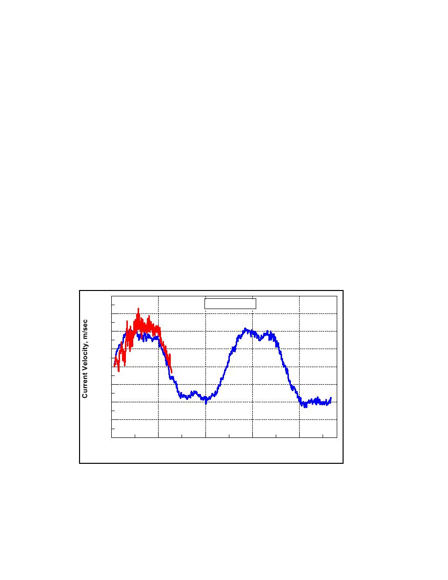
A maximum velocity of 0.43 m/sec was recorded at Current Meter 1, and
instantaneous velocities exceeding 0.50 m/sec were recorded at Current Meter 2 (Figure
3-24). The second half of the data record from Current Meter 2, which failed after about
11 hr, was considered questionable and is not presented. Flood current is directed
positive and ebb current is directed negative. The maxima on 8 October 2002 correspond
to the near maximum water elevation at spring tide (Figure 3-23b). This instrument was
secured to a floating barge, and the high-frequency fluctuations are attributable to
movement of the barge with surface waves and wind. The velocity phases and
magnitudes at both locations are consistent. Relative velocities at these point
measurements are not readily compared because of the different water depths and
proximities of the gauges to the channel or jetty. The measurements show plateaus in the
maxima and minima, indicative of nonlinearities in water motion due to tidal wave
shoaling and bottom friction.
0.8
Mattituck Inlet
0.6
Meter 2
0.4
0.2
0.0
-0.2
Meter 1
-0.4
-0.6
-0.8
13:00
9:00
23:00
23:00
4:00
18:00
8 October 2002
7 October 2002
GMT
Figure 3-24. Mattituck Inlet along-channel current velocity, 7-8 October 2002
68
Chapter 3 Field Data Collection and Analysis

 Previous Page
